Beginner's Guide
Solar System - Artificial Satellites
So Many Satellites

|
|
International Space Station |
The Earth has one natural satellite: the moon. As of 2021 there are over 6500 artificial satellites, about half of them are active. This is an amazing number when before 1957 (65 years ago), there were none.
Have you seen an artificial satellite in the night sky? Chances are you have if you're paying attention since there are so many and they can appear in any part of the sky. All the artificial satellites look like a star to the naked-eye, but in motion against the background. It can be easy to mistake an airplane, but they usually give themselves away with their blinking lights whereas a satellite has more consistent light as they are being illuminated by the sun. Of course if you have binoculars that will help, and you can even try to spot it in a telescope. And if you look at the sky long enough with a telescope you'll see fainter satellites pass by in the field of view, especially during the early evening or in the early morning.
In recent years there is much more media attention to these satellites. The International Space Station (ISS) is by far the largest and by far the most famous artificial satellite. It's also the biggest and brightest. But there is also a whole new class of them best represented by the Starlink Satellites. These will appear in the sky as multiple "stars" in a long string, all traveling in the same direction.
Using An Ephemeris
An ephemeris is a table (or tables) giving the coordinates of a celestial body at a number of specific times during a given period. These were traditionally published in books and magazines, but these days there are various internet sites to give this information. And it's very personalized because you can input your exact location and various other parameters to narrow the search.

Above you see a prediction for sighting the ISS (International Space Station) from the In-The-Sky.org website. It gives a lot of useful information beyond just the time. You should find this diagram useful to understand the info:

Though we hope this diagram demonstrates where to look for any given satellite, there is a bit more you should understand. This particular emphemeris for the ISS is in the early evening. The appearance is when you can first reasonably see it. And it will be the brightest when it's is highest in the sky. But keep in mind that the ISS (as are all the artificial satellites) are illuminated by the sun. So you only really see a satellite when it's in the sunlight. At the end of the sighting you'll see that it disappears well before it gets to the horizon. That is because the satellite will move into the Earth's shadow.

At the right of the ephemeris from In-The-Sky.org, they have a column labeled "Diagram of Pass" and below it links labeled "Chart..." If you click/tap on that link it will bring up a diagram which charts that satellite pass. In this particular example you'll note that the path goes fairly far before disappearing. This indicates that this pass was not very long after sunset.
Constellation Satellites
 Constellation satellites are
groups of satellites that work together as a system. The reason for the many satellites is they can provide global (or near global) coverage.
This means at any given time one or more of these satellites is in the local sky.
Constellation satellites are
groups of satellites that work together as a system. The reason for the many satellites is they can provide global (or near global) coverage.
This means at any given time one or more of these satellites is in the local sky.
The most famous of this type of satellites is Global Positioning System (GPS). The animation at the right shows their movement over one full day. There are 31 satellites and they are positioned at half geosynronus position (20,180 km / 12,540 mi above Earth's surface so they do one orbit every 12 hours.
A relatively new satellite constellation is Starlink which are being launched by SpaceX.

Above is a simulated display of Starlink satellites. The all move in unison in the same direction as the chain. But there are other Starlink chains where the satellites are much closer to one another!
Wikipedia image of ISS
MAS image of the ISS
ISS across the Sun - Jeff
Geosynronus Satellites
 Geosynronus satellites are a very special class of satellites. They all orbit approximately 35,786 km (22,236 miles) along about our equator. This
altitude is special because at this altitude, their orbital period (1436 minutes = one
sideral day)
matches Earth's rotation period and the satellites hover over the same spot as
shown in the animation at the right.
This makes them ideal for communicating television and radio as a dish once pointed at any given satellite does not need to move. The satellite will
remain in that exact position.
Geosynronus satellites are a very special class of satellites. They all orbit approximately 35,786 km (22,236 miles) along about our equator. This
altitude is special because at this altitude, their orbital period (1436 minutes = one
sideral day)
matches Earth's rotation period and the satellites hover over the same spot as
shown in the animation at the right.
This makes them ideal for communicating television and radio as a dish once pointed at any given satellite does not need to move. The satellite will
remain in that exact position.
Because of their distance they are somewhat faint (10th to 12th magnitude) so you will need a telescope to see them, one with an aperture of at least 4 inches (10 cm). At first glance you may think there is really nothing to see, but the reality is the view is amazing. If your telescope doesn't have a clock drive or it's turned off, the satellite will remain stationary and all the stars in the field will drift by. If you have a clock drive and it's engaged, the stars will remain fixed and the satellite will drift.
So what geosynchronus satellite should you observe? It really doesn't matter. There are well over 500 of these satellites with more being launched over time. What you need to know is the declination of the orbit as seen from your position on Earth. If you are observing from the Equator it's very simple: the satellites will be seen at 0° so directly on the celestial equator. But if your latitude is north of the equator, the satellites will appear south of the celestial equator; if your latitude is south, the they will appear north of the celestial equator.
Below we give you a table of latitudes and the celestial declination of where to find the satellites. You can see that the more northern you are, the further south they will appear (and reversed in the southern hemisphere.) But to more precisely find the declination, we provide a calculation tool below.
Declination Table
| Latitude |
Declination |
|---|---|
0° |
0.00° |
10° |
-1.77° |
20° |
-3.45° |
30° |
-4.97° |
40° |
-6.28° |
50° |
-7.31° |
60° |
-8.07° |
70° |
-8.53° |
80° |
-8.70° |
Custom Calculation For Your Latitude
Enter your own latitude for the declination calculation.
Currently: Latitude = 43.0° gives a declination of -6.62°
As an example of how you would use this declination calculation, we will use Milwaukee as our example which has a latitude of about 43 degrees.
Our first example is in the summer sky along the Milky Way in the constellation Scutum (the shield) where there is a very convenient signpost just north of the location: M11, the Wild Duck Cluster.
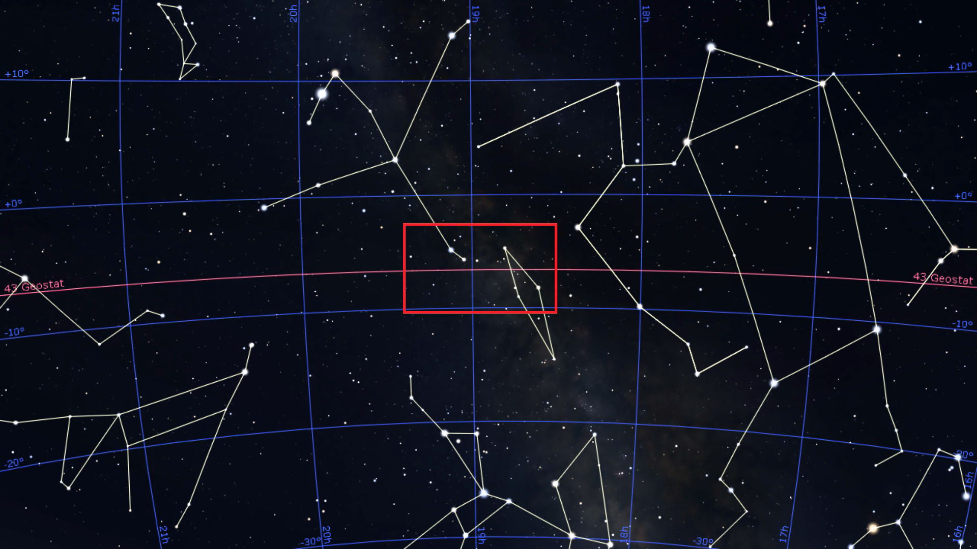
The sky diagram above from Stellarium is of the summer sky centered around the constellation Scutum. The bright star to the upper left is Altair which is one of the three stars of the Summer Triangle. Below we will zoom in on the area shown by the red box. The reddish line marked 43 Geostat is the declination of where the geosynchronus satellites orbit as seen from 43° north latitude.
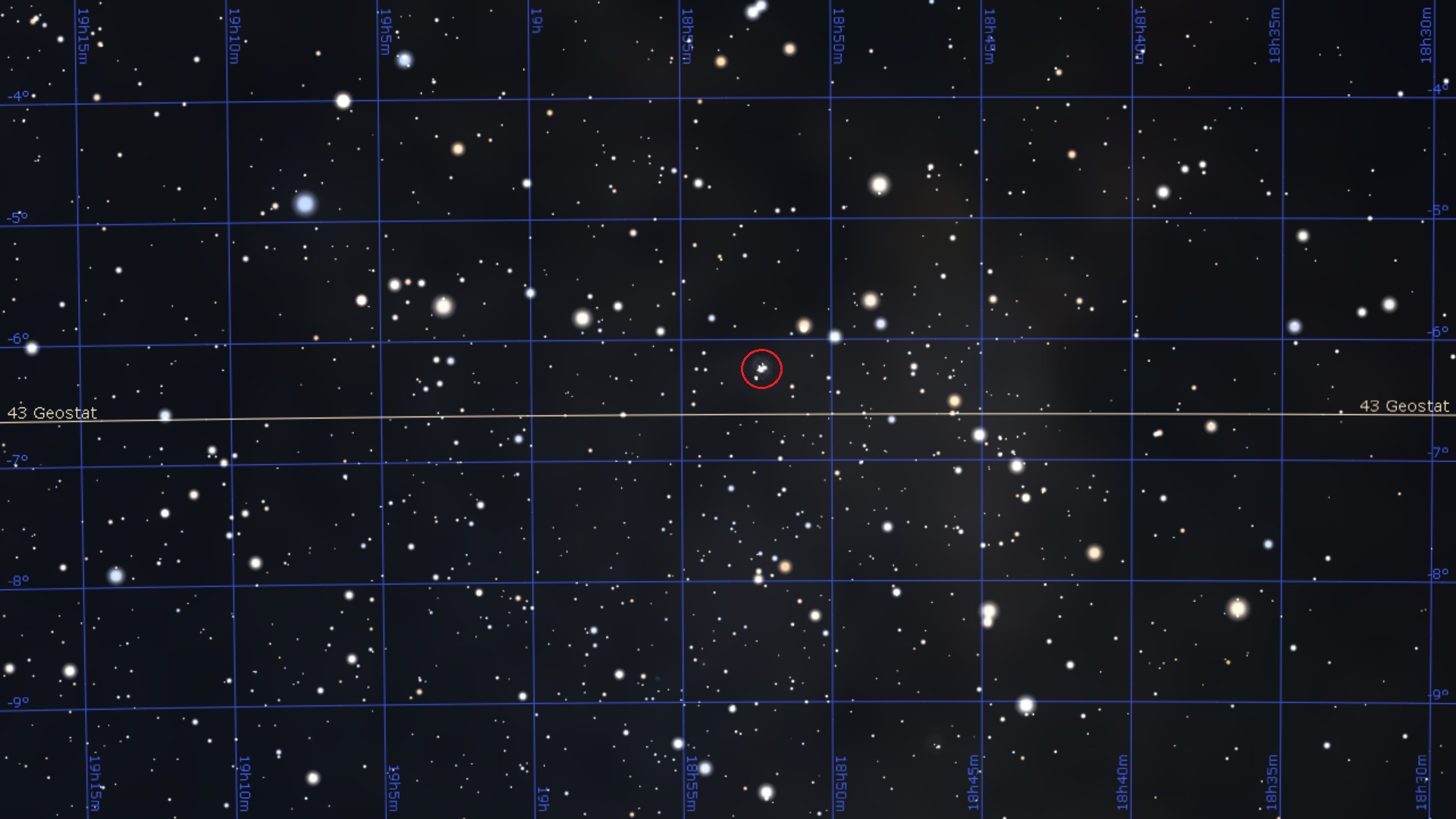
The diagram above is the zoomed in area centered on M11, the Wild Duck Cluster (in the red circle) which is fairly easily seen in a 8X50 finder scope. As you can see the declination line for 43° is just south of this object.
Please keep in mind that there is nothing actually special about this location as far as viewing the satellites is concerned as that can be done anywhere on that line. It's just a convenient location for finding the line.
Our second example is in the winter sky in the constellation Orion where there is a very convenient signpost just north of the location: M42, the Orion Nebula.
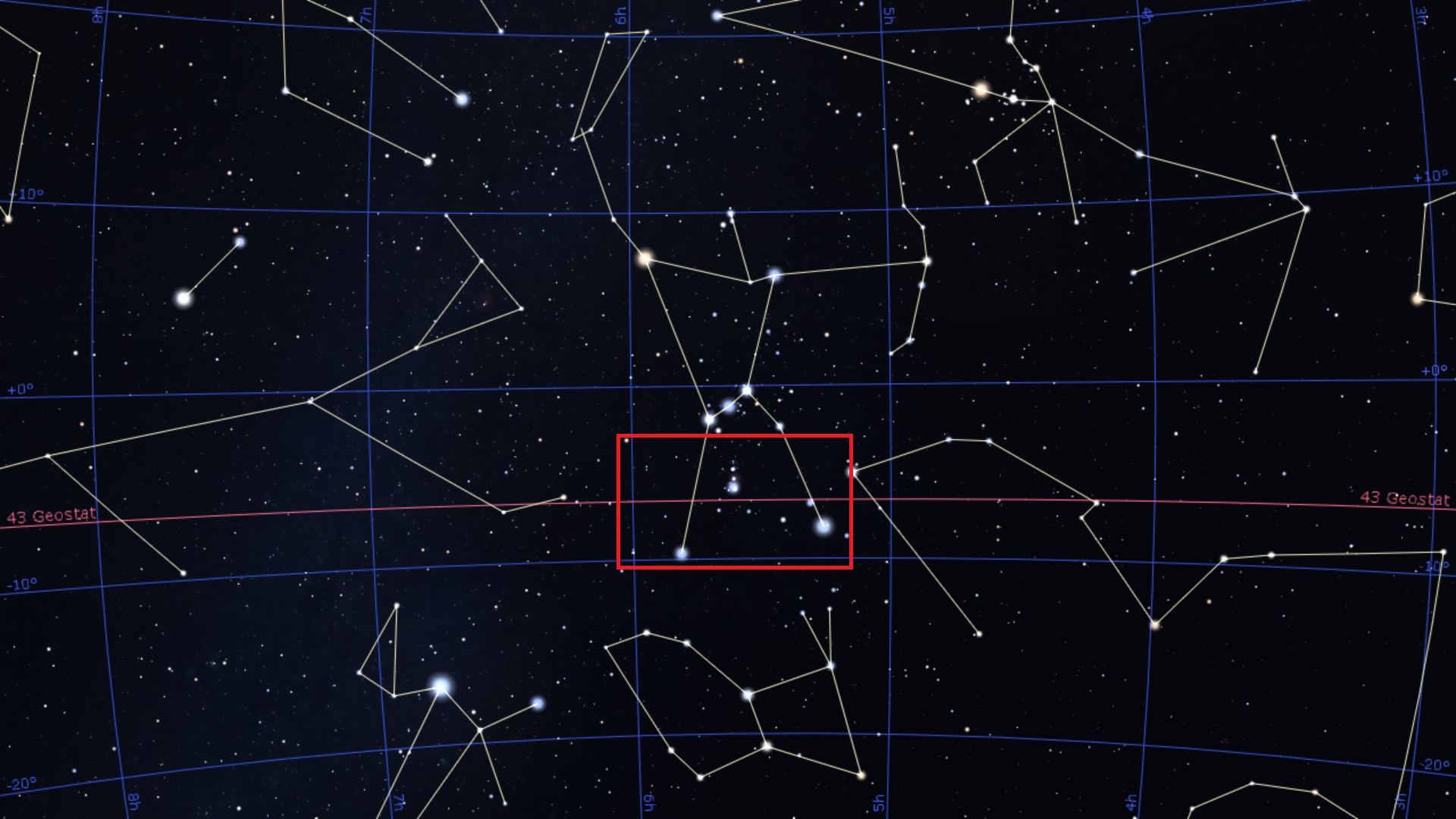
The sky diagram above from Stellarium is of the winter sky centered around the constellation Orion. Below we will zoom in on the area shown by the red box. The reddish line marked 43 Geostat is the declination of where the geosynchronus satellites orbit as seen from 43° north latitude.

The diagram above is the zoomed in area centered on M42, the Orion Nebula (in the red circle) which is can actually be seen by the naked-eye and easily easily seen in a 8X50 finder scope. As you can see the declination line for 43° is just south of this object.
Viewing Through a Telescope

|
|
ISS Transits the Moon. Wikipedia Commons. |
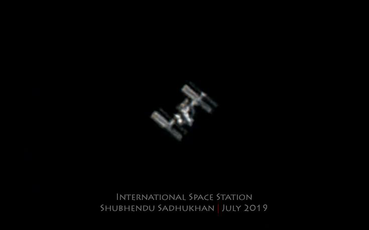 |
| International Space Station imaged by MAS member Shubhendu Sadhukhan. |
Another problem is that from a size standpoint you'd like to have it pass directly overhead. However, directly overhead can be difficult to navigate with your telescope plus when at overhead or near overhead, the apparent speed of the ISS is the fastest. At 45°-60° the size is smaller, but the ISS is moving slower which makes it easier to track and view. Your best case scenario is where you can acquire the ISS when it's relatively low in the sky when it's moving much slower, and then keep it view as it gets higher when it will be larger but moving faster.
Practice
If you're really going to try to view the ISS in your telescope, we suggest practicing what you need to do. We suggest any aircraft as your target because the acquisition and then viewing well simulates what will happen with the ISS.
ISS Transits
One relatively easy way to catch a glimpse of the ISS in a telescope is during a solar or lunar transit. What do we mean by "relatively?" The ISS moves across the sky fairly quickly and that transit will only last at most a half second. Then these transits are fairly rare so advanced planning will be required so you're in the right place at the right time. We recommend the use of Sky & Telescopes Satellite Tracker for planning purposes. It also will show planetary transits as well, but those are extremely rare and the event happens in less than a blink of the eye.
Because these events happen so quickly, most imagers will do a video capture, normally at 30 frames per second. Here are a couple of examples made by a member of the Milwaukee Astronomical Society.
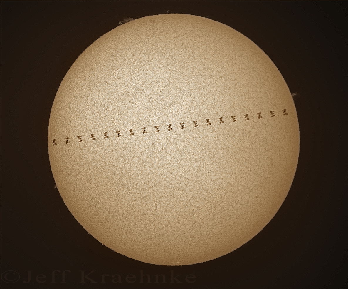
June 28, 2020. 10:38AM. Altitude: 65°. Jeff Kraehnke, MAS Image.
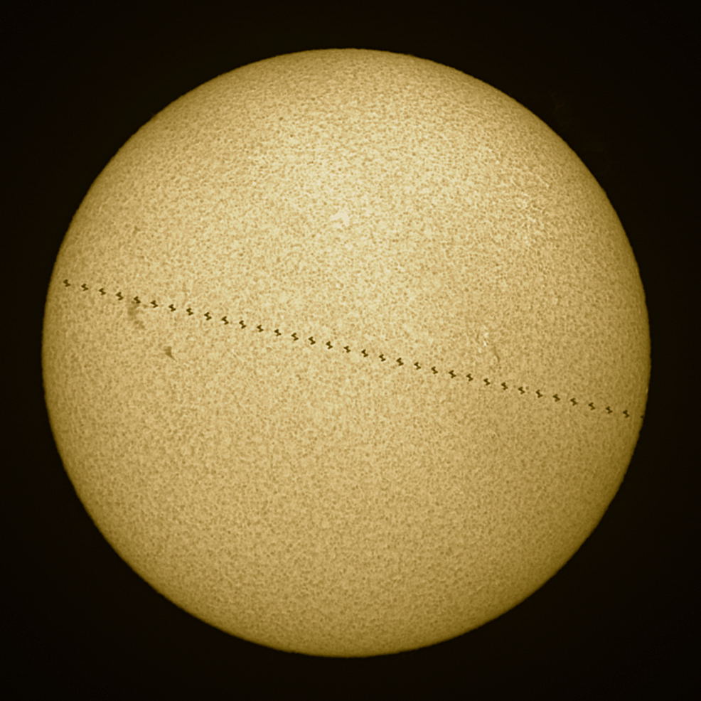
July 4, 2020. 07:27AM. Altitude: 31°. Jeff Kraehnke. MAS Image.
| Warning: Observing the Sun is dangerous! |
And since we've mentioned observing the Sun, we have to inform you there are precautions you need to follow to do so safely. More information can be found here.